
Settling the Lowlands
How modern Jewish settlement in the valleys transformed the land

While most of the post-independence Jewish communities in the Galilee were built at an altitude of 250 meters or more (the same altitude as most Arab communities in the area), most Jewish settlements during the First and Second Aliyah (1881 – 1914) were built in the valleys and plains. Why? First, we need to understand the Ottoman land system on the eve of modern Zionism. Rural lands were usually classified according to several categories: miri (state-owned agricultural land), mülk (private property), waqf (religious endowments), and matruka/mawat (communal/uncultivated lands). For centuries, peasants had worked miri lands without formal ownership.
The Ottoman Land Code of 1858 was a watershed moment in the region’s land tenure system. Now, the Ottomans required land registration with formal title deeds (tabu). The goal was greater centralization, but it inadvertently allowed wealthy notables to register vast tracts of land previously cultivated by peasants who either didn’t understand the system or feared registration would result in greater taxation and military conscription. This created the conditions that later facilitated large-scale land purchases by the Zionist movement, which by 1914 had acquired around 418,000 dunams (41,800 hectares), more than two-thirds in lowland areas.
The valleys were paradoxically more fertile while facing several drawbacks in the form of greater heat, humidity, and malaria-carrying mosquitos. Furthermore, the presence of water in places like the Hula Valley had attracted predatory Bedouin pastoralists seeking water for their livestock. The seasonal movement of Bedouin tribes created zones of instability in these lowland regions, particularly when central Ottoman authority weakened in the empire’s periphery. Historical documents frequently attest to complaints from settled communities about Bedouin raids on crops and livestock. For example, between the sixteenth and nineteenth centuries, up to 85 percent of the villages in the Beit She’an and Jezreel Valleys were abandoned, in contrast to only 6–10 percent of Palestine’s hillside villages. The closer these low-lying communities were to the Bedouin sphere of influence, the more likely they were to be abandoned. “Where the Bedouin roamed and pillaged, Arab agriculture and permanent rural settlements were rare,” Gerald David Sack writes in his article ‘Factors influencing the location of the early Zionist settlements in Ottoman Palestine: 1880-1915.’
It was these lowland areas that were described as “empty” by European travellers, leading to the myth of a “land without a people for a people without a land.” Used to densely populated agricultural regions in their valleys back home, they wrongly interpreted the relatively uninhabited valleys as evidence of general underpopulation. Ironically, even though the Bible told a similar story, they failed to recognize the ecological and security adaptations that had shaped settlement patterns for millennia. British mapmaker and explorer Claude Reignier Conder noted this discrepancy in his 1878 Tent Work in Palestine: A Record of Discovery and Adventuring, observing that “the highlands of Palestine are far more densely populated than casual travellers might suppose.”
Most of the lowland areas were owned by either local or ‘foreign’ notables from Egypt, Lebanon, and Syria, who had purchased them from the Ottoman government in the second half of the nineteenth century following the Ottoman Land Code reforms. In mountainous areas, it was more difficult to purchase land, because a system of communal land tenure (musha) dominated, meaning that village land was periodically redistributed among families. This made it difficult to engage in large-scale land acquisition. The communal system also fostered stronger connections between villagers and their land, making them less willing to sell.
Throughout the history of the land, people have preferred settling on higher ground. Less fertile soil meant less plunder for raiders, and fewer visits from tax collectors. At higher elevations there is also more limestone available, and springs. Sacks writes: “Thus, the Arab preference for settlements at high elevations provided security, building materials, and also an efficient ecological adaptation to the environment.” Homes were usually built on slopes rather than arable land, preserving valuable cultivation space, while ancient terracing techniques (mentioned in Isaiah 5:1-2 and possibly Psalm 65:10-13) maximized agricultural potential on hillsides. Cisterns captured rainwater during wet winter months for use during dry summers. This settlement pattern dates all the way back to the Bronze Age, which is why population centers have consistently been found in the hill country of Judea, Samaria, and the Galilee. In this regard, Palestine mirrored patterns throughout the Mediterranean. Higher elevations provided natural defensive positions, better climate conditions, and reduced exposure to diseases prevalent at low altitudes.
Down in the valleys, mechanized grain farms were established on the Western European model familiar to the Ashkenazi olim. “Thus, economies of scale and a specific choice of crops also influenced the initial Zionist land purchases in late nineteenth century Palestine,” Sacks writes. The flat terrain of valleys and plains was ideally suited to mechanized agriculture, allowing for economies of scale impossible in highland regions. In July 1937, after the Zionist movement had spread throughout the valleys and plains, Ben-Gurion wrote in his diary: “With the evacuation of the Arab community from the valleys [of Palestine] we achieve, for the first time in our history, a real Jewish state – an agricultural body of one or more million people…at one with its land which is completely its own.” Early Jewish settlements like Degania and Nahalal pioneered agricultural cooperatives that maximized efficiency through shared equipment and coordinated planting. Lest anyone think this was a purely ‘settler colonial’ initiative, large-scale Arab agriculturalists did the same in parts of the coastal plains, and in the one area of the West Bank with fertile plains – the Nablus district – demonstrating parallel agricultural modernization trends.
The prevalence of malaria in the lowlands was the most significant deterrent to settlement. The Anopheles mosquito, which transmits the disease, thrives in swamps, marshes, and poorly drained agricultural areas like the Hula and Jezreel Valleys. Medical records from Ottoman Palestine document significantly higher mortality rates in lowland communities compared to highland ones, with malaria the primary cause. In some lowland areas, up to 30% of the population suffered from the disease each year, with particularly high mortality among children and the elderly. The Zionist movement pioneered comprehensive anti-malaria efforts including drainage projects, mosquito larvae control using petroleum products, and distribution of quinine. These public health initiatives transformed these areas into productive agricultural land (but came with their own drawbacks, as the later draining of the Hula Valley would show). As a result, settlement maps overlaid with historical malaria prevalence data are remarkably similar.
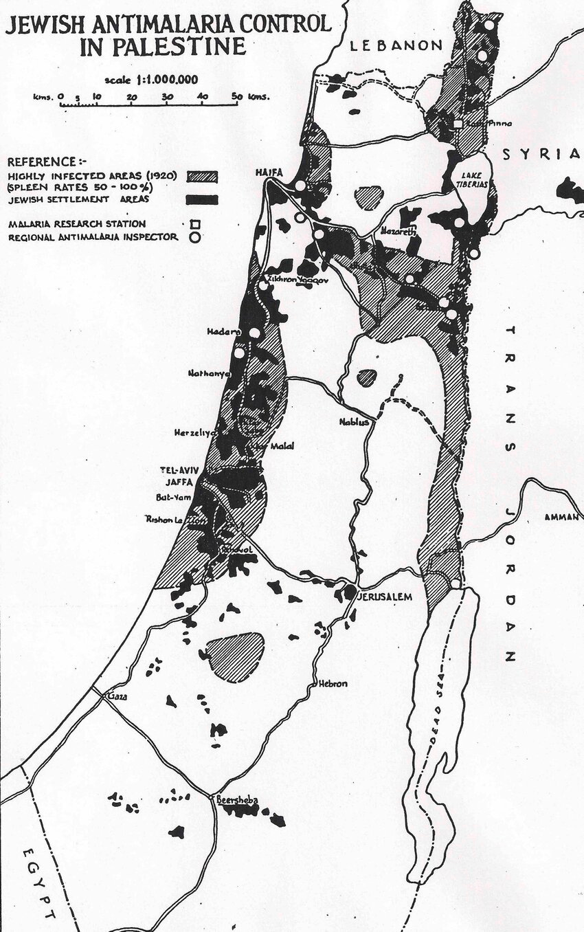
The impact of these settlement patterns has been profound. The coastal plain, where (for reasons which should now be clear) there was very little Jewish settlement in ancient times, now contains Israel’s major population centers, while development in the valleys has resulted in Israel’s robust agricultural sector, which despite limited water resources has achieved remarkable productivity. What once were disease-ridden marshlands have been transformed into the demographic and economic heart of modern Israel, hosting over 70% of the country’s population and generating the majority of its GDP. Thus, the decision to purchase and settle the malaria-infested lowlands that most others had avoided (which was partly because the best agricultural land wasn’t available) ultimately redrew not just the map of settlement patterns, but the entire demographic, economic, and political landscape of the land.